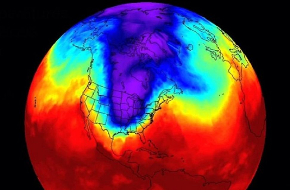
The most severe
outbreak of frigid arctic air in years is set to surge over the Upper Midwest
and Great Lakes by the middle of next week. A large lobe of the polar vortex,
the zone of frigid air winding around the North Pole, is breaking off, and
temperatures will plunge as much as 40 degrees Fahrenheit (22 degrees Celsius)
below normal close to its core.
Some of this
teeth-chattering cold will spill into the Mid-Atlantic and Northeast as well,
but it won't be quite as extreme. The hardest-hit zone will span from Minnesota
and Iowa through Michigan, including Minneapolis, Des Moines, Green Bay,
Milwaukee, Madison, Chicago, Indianapolis and Detroit.
“Wind chills ... should be the coldest since the mid-1990s in parts of the eastern Dakotas, Minnesota, Iowa, Wisconsin and northern Illinois,” tweeted the National Weather Service.
Frigid air has
already leaked south of the Canadian border. Madison, Wisconsin's
temperature sank to a
record-crushing -23°F (-30°C) on Saturday, its lowest temperature in nearly
23 years. On Sunday, International Falls, Minnesota tumbled to -46°F
(-43°C), the fifth lowest temperature it has ever recorded. Extreme cold is
expected to cover a much larger area Tuesday through Thursday, sweeping
southeast through Illinois and into the Ohio Valley.
Brutally cold temperatures and potentially life threatening wind chills will be the rule across northern Illinois and northwest Indiana by midweek. During the coldest period Tuesday night thru Wednesday night, wind chills are expected to fall below -40 degrees in many locations. pic.twitter.com/ufY8U5mZCO— NWS Chicago (@NWSChicago) January 27, 2019
“There's no mild way of saying it. Brutal cold is coming,” the National Weather Service office serving Chicago tweeted.
It is predicting air temperatures close to -20°F and wind
chills of -35°F to -45°F Wednesday morning.
Chicago's high
temperature may remain below -11°F on Wednesday, which would signify its
coldest afternoon in recorded history. There is an outside chance low
temperatures in the Windy City touch -20°F on consecutive days Wednesday and
Thursday, which has happened only four other times
in recorded history. The Weather Service office serving Chicago is
predicting temperatures will remain below zero for 60 consecutive hours, from
Tuesday afternoon through Thursday.
“Only eight times since 1872 has Chicago recorded subzero highs on at least two consecutive days, the most recent being early February 1996,” it said.
Milwaukee and
Madison also face bone-chilling cold. In its forecast discussion for the
region, the Weather Service wrote that the danger of the predicted temperatures
“can't be overstated,” noting they will be 30 to 40°F (17 to 22°C) below
normal. “For January, that's incredible,” it said. In Des Moines, where the
wind chill may dip to -40°F on Wednesday, the Weather Service is not mincing
words.
Wind chills will fall to dangerous levels in the Upper Midwest this week, and should be the coldest since the mid-1990s in parts of the eastern Dakotas, Minnesota, Iowa, Wisconsin and northern Illinois. Wind chills falling below -40 can cause frostbite on exposed skin in minutes. pic.twitter.com/FFVZe1xGhD— NWS WPC (@NWSWPC) January 27, 2019
“THIS HAS THE POTENTIAL TO BE LIFE-THREATENING COLD AIR!!!,” its forecast discussion said. “This is the coldest air many of us will have ever experienced.”
It warned
frostbite can occur to exposed skin within minutes under such conditions.
“Make sure your heating system, pipes, etc. are as well-prepared as possible,” it advised. “It may be wise to stock up on groceries between now and Monday evening so outdoor time is minimized.”
The low
temperature in Minneapolis may fall to near -25°F Wednesday and Thursday
mornings while wind chills could plummet to -50°F (-46°C). "There's no
sugarcoating it, the weather will get extremely cold," tweeted the
Weather Service office serving the Twin Cities. Parts of northern Minnesota may
see air temperatures below -30°F and wind chills of -55 to -60°F (-61°C).
Wind chills may
plunge to -30°F around Detroit on Wednesday and Thursday mornings, and
"frostbite and hypothermia may become serious concerns," the Weather
Service serving the Motor City
tweeted. The cold wave, which should begin to wane Friday into the weekend,
is likely to set numerous records. Many locations are predicted to challenge
their coldest high temperatures for January 30 on Wednesday, and a number of
record lows may be set Wednesday and Thursday mornings.
The entirety of
Minnesota and Wisconsin and much of northern Illinois is expected to remain
below zero for all of Wednesday.
“This is a bonafide arctic airmass,” tweeted Sam Lillo, a meteorology researcher at the University of Oklahoma, noting temperatures at high altitudes may rival the coldest ever recorded in the contiguous United States.
Some of the cold
from this arctic blast will reach the Mid-Atlantic and Northeast, but its
intensity is likely to ease as it nears the coast - with the more extreme
conditions in the interior. Temperatures may fall 10 to 25°F (5 to 13°C) below
normal Wednesday through Friday but probably won't be record-breaking.
This article was
originally published by The
Washington Post.
Comments
Post a Comment